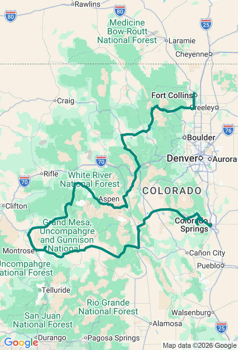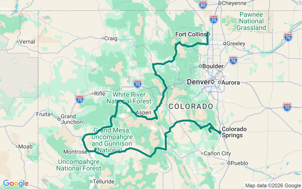
Northbound — climb Pikes Peak first, while the summit is still clear, then west and north through canyon country to Carbondale. Day two crosses Independence Pass early, runs the Blue River up to Kremmling, and comes into Rocky Mountain National Park the hard way, over Trail Ridge Road from the west.
Over the top twice in two days
Most Colorado trips spend their days looking up at the high country. This one goes over the top of it three times, and does it in a weekend.
The shape is simple and the days are not. Three times above treeline — the Pikes Peak summit at 14,115 feet, Independence Pass at 12,095, Trail Ridge Road at 12,183 — with canyon country strung between them that most people drive past on their way somewhere else. Four national park units sit along the way. It is a lot of ground for two days, and the plan only works if you treat the mornings as the point rather than the price.
Which is why day one starts in Colorado Springs the night before. Take a room in town, be at breakfast when it opens, and be climbing while the summit is still clear. Breakfast is Uncle Sam's Pancake House on Manitou Avenue, at the foot of the mountain — pancakes the size of the plate, which is the correct fuel for what follows and the wrong fuel for almost anything else.
Then up. The Pikes Peak Highway is nineteen miles of toll road that climbs a fourteener — one of the very few anywhere you can drive to the top of — and it does not care that you are on a schedule. Above treeline the air thins enough that engines lose noticeable power and brakes stop behaving the way you expect on the way back down — there is a mandatory check partway through the descent, and it exists for good reason. Give the mountain two hours and do not resent them.
Back at the bottom, the day turns west and gets quiet. Florissant Fossil Beds is thirty-odd miles on, and it is the strangest stop of the trip: petrified redwood stumps the width of a room, left over from a forest that stood here around thirty-four million years ago, before the mountains you just climbed finished arriving. It takes twenty minutes and recalibrates the scale of everything after it.
From there US-24 and US-285 drop you toward the Arkansas River and Browns Canyon, where the water does the work — a rafting canyon that reads as pure granite and whitewater from the road. Then the long westward push to Black Canyon of the Gunnison, which is the one people underestimate. It is not wide and it is not gentle. It is a slot up to two thousand seven hundred feet deep, so narrow and so sheer that parts of the floor get roughly half an hour of direct sun a day. The Painted Wall — Colorado's tallest cliff at around 2,250 feet — is a short walk from the rim road. Stand at one overlook, then get back in the saddle.
Day one ends north in Carbondale, under Mount Sopris, with dinner at The Tavern on Main Street and a night at the Crystal River KOA. It is a long day. Four hundred miles and a fourteen-thousand-foot mountain is a lot to ask, and you will feel the altitude in your sleep.
Day two is shorter and it is the better of the two. Breakfast at Poppycock's Cafe in Aspen, then straight onto CO-82 and up. Independence Pass is the highest paved crossing of the Continental Divide in Colorado, and the road earns that with a narrow, guardrail-light climb through switchbacks above the treeline. It is gated from roughly November to late May, which is most of the reason this trip has a season.
Over the top, the road spills into Leadville — at 10,152 feet, the highest incorporated city in the country, and a place that has never quite stopped looking like the silver boom that built it. Then the day turns north and gets quiet again: up the Blue River on CO-9, along the shore of Green Mountain Reservoir at Heeney, and out into ranch country at Kremmling, where the Colorado River is still narrow enough to look like a trout stream rather than a canyon-cutter.
East on US-40 through Hot Sulphur Springs and Granby, and then the last climb, which is the one to save your camera for. Trail Ridge Road enters Rocky Mountain National Park from the west and crosses at 12,183 feet — the highest continuous paved road in the United States, eleven miles of it above treeline, with the tundra falling away on both sides and no trees left to give you a sense of scale. It closes for the season even earlier than Independence Pass does.
The road comes down into Estes Park, and from there the plan drops Big Thompson Canyon to Fort Collins — dinner at Blue Agave Grill on College Avenue and a night at the Lakeside KOA. Two days, three crossings above treeline, and a fair argument that you have seen the top of Colorado.
And hold it loosely. Three trips above treeline and four parks in two days is a plan that will not survive first contact with a good afternoon — and it shouldn't. If the light is doing something at the Black Canyon rim, stay and lose an hour. If a pullout on Independence Pass has nobody on it, that pullout is the trip. The route is here so you can wander off it without doing fuel math on the shoulder in the dark. The best stop on a day like this is almost always the one nobody wrote down.