
A number is going around. Ninety percent.
Depending on where you heard it, it means one of two things. Either the President cut two national monuments by ninety percent, or he cut the National Park Service budget by ninety percent. One of those is accurate. The other is off by a factor of about ten.
This is a road trip site, so the question I care about is a narrow one: if you were planning to drive southern Utah, does any of this change your trip? I went and read the proclamations. Here is the report.
The short version
- The proclamations closed nothing. No visitor centers, no campgrounds, no roads. Both monuments are open, and the land stays federal public land either way.
- The lawsuits finally arrived — on September 2, seven weeks and two days after signing. Two coalitions of conservation groups asked the federal court in Washington to reopen the 2017 cases and add this year's proclamations to them. The five tribes have filed nothing of their own but told the court on September 8 that they support the motions; the government’s answer is due September 16. Nothing is stayed: the reduced boundaries stand while the court decides whether to even take the cases back up.
- A wildfire did close things — and that's the part that affected a trip. The lightning-caused Babylon Fire burned 107,189 acres through Bears Ears from June 26 and closed much of the country for seven weeks. It is out, and on August 20 the Forest Service lifted the last of its closure eleven days early. Everything is open again. What the fire leaves behind is flood risk: burned ground sheds water for years, and the first big storms of the monsoon came through at the end of August. Nothing in the burn scar has been posted closed since, and the forest dropped its fire restrictions on September 4 — so the thing to check now is the road report, not a closure order. None of this has anything to do with the proclamations.
- The 90% figure is real — for acreage. Bears Ears fell 91.1%, Grand Staircase-Escalante 90.3%. About 2.93 million acres left monument status.
- The "90% parks budget cut" is false. Congress funded the Park Service and BLM at 2% below last year, back in January. Neither monument is even a national park.
- The one date in the proclamations has arrived. At 9 a.m. Eastern on September 11 the removed land opened to mining claims and mineral leasing — 60 days after signing, not immediately, whatever the July headlines said. Nine claims were filed early anyway, and the proclamations say those vest no rights; three days after the opening, nobody has reported a tenth. BLM published nothing about the opening; its field manager's word for it, reported two days before, was that not much changes on the landscape immediately. A claim is a filing, not a mine.
- The proclamation also ended the Bears Ears tribal commission — and around July 22, the five tribes' seals came off the monument's signs. Signage is the only physical change the proclamations have produced so far.
- The new boundaries are finally mappable. BLM published the coordinate data around August 3, three weeks after the signing. The map on this page is drawn from it.
- Scenic Byway 12 runs exactly as it did. It's a state highway. A monument boundary doesn't close it.
What did Trump actually sign?
On Monday, July 13, 2026, President Trump signed two presidential proclamations under the Antiquities Act. One modifies Bears Ears National Monument. One modifies Grand Staircase-Escalante National Monument. Both are in Utah.
They are proclamations, not executive orders. A fair number of outlets have called them executive orders. It is a small distinction, but boundary changes under the Antiquities Act are made by proclamation, and if you go looking for an executive order you will not find one.
They were published in the Federal Register on July 17, 2026 — Bears Ears as Proclamation 11043 and Grand Staircase-Escalante as Proclamation 11044. If you see a story citing "Proclamation 9558," set it aside — that is Obama's 2016 proclamation establishing Bears Ears, cited inside the new order as a prior instrument. It is not the order itself.
Is the 90% cut real? Yes — but it's acreage
Here is what the two proclamations do:
- Bears Ears — from approximately 1.36 million acres to approximately 121,096 acres. A 91.1% reduction. What remains is two units: Shash Jáa (~106,816 acres) and Indian Creek (~14,279 acres).
- Grand Staircase-Escalante — from approximately 1.87 million acres to approximately 181,541 acres. A 90.3% reduction. What remains is two units: the Canyons of the Escalante Unit and the Kaiparowits Horizon Unit.
Combined, the two go from about 3.23 million acres to about 302,600 acres. Roughly 2.93 million acres leave monument status. For scale, the pre-cut footprint was close to the size of Connecticut.
So the ninety percent figure holds. If anything, it rounds down.
I want to be plain about the sourcing, because this is the part people will argue over. These numbers are not from a press release I decided to trust. They are in the proclamation text and the White House fact sheet. They are also confirmed, independently, by the organizations preparing to sue over them — Earthjustice puts Bears Ears at 8.9% of its prior size and Grand Staircase at 9.7%, which is the same arithmetic from the other direction. Nobody disputes the acreage. The dispute is about the law.
Status of this story
as of September 14, 2026Was the national parks budget cut by 90%? No
The other ninety percent story says the National Park Service budget was cut by ninety percent. It was not.
Congress enacted the FY2026 budget on January 23, 2026, in P.L. 119-74:
- National Park Service — $3.267 billion. That is 2% below FY2025.
- Bureau of Land Management — $1.378 billion. Also 2% below FY2025.
Both agencies took a two percent trim. Not ninety. A ninety percent cut would have left BLM at roughly $141 million against its FY2025 base; the real appropriation, $1.378 billion, is nearly ten times that.
Where the number probably came from: the administration requested much deeper cuts — 37% for the Park Service, about 36% for BLM. Congress rejected them and funded both well above the request. Separately, the administration proposed a roughly 93% cut to one small Park Service account called National Recreation and Preservation. That account is about 2.8% of the NPS budget, and Congress ended up funding it at $91.6 million, a 2% increase.
So there is a real ninety-something in the budget story. It is a proposal that did not pass, and it applies to a sliver.
Are these national parks? No — and that matters
This is the part that undoes the budget framing completely.
Neither Bears Ears nor Grand Staircase-Escalante is a National Park Service unit. Grand Staircase-Escalante is managed by the Bureau of Land Management. Bears Ears is managed jointly by the BLM and the U.S. Forest Service. The Park Service does not administer either one.
Its budget and these boundaries are unrelated things. Anyone telling you the national parks were cut by ninety percent is wrong twice — wrong about the number, and wrong about the agency.
The new boundaries, mapped
Here is the cut on the ground, drawn from the Bureau of Land Management's own boundary data. The gray is what left monument status on July 13. The colored islands inside it are what's left.
Both layers come from BLM Utah's National Conservation Lands service — the gray captured from it on July 12, the colored units read from it on August 3 and re-checked, unchanged, every week since — most recently September 8. We checked the new data against the proclamations before drawing it: the service returns 121,039 acres for Bears Ears and 181,451 for Grand Staircase-Escalante, against the proclamations' 121,096 and 181,541. Within Bears Ears, the northern island sums to about 14,200 acres and the southern group to about 106,000 — matching the Indian Creek and Shash Jáa unit figures. That is four independent numbers agreeing, so we're satisfied this is the real thing rather than a partial or staged update. Switch to terrain or satellite to see what the acreage actually covers.
Two honest caveats. BLM updated the shapes but not the labels — the records still carry no unit names and still cite the 2021 restoration proclamation, so the units are drawn from geography, not from a field that names them. And the outlines are simplified to about 150 meters for page weight, which is fine for reading the shape of the thing and not fine for deciding whether one specific parcel is inside or out. For that, use the official maps below or BLM directly.
One note for the detail-minded: the old Bears Ears outline encloses about 1.49 million acres, while the proclamation counted 1.36 million. That gap is roughly 109,000 acres of state school-trust land plus private parcels sitting inside the boundary. The proclamation counts federal land; the map draws the outer edge.
Combined monument acreage · to scale
Bars are proportional to the acreage figures in the two proclamations. This is arithmetic, not geography — it shows how much, not which parts.
The boundary data finally landed
For three weeks the honest answer to "where exactly are the new lines?" was: nobody outside the government could plot them.
When they were signed, each proclamation defined its monument by reference to "the accompanying map, which is attached to and forms a part of this proclamation" — and that map was not posted with the text. That changed on July 17, when the Federal Register published both proclamations in full, official numbers (11043 and 11044) and attached boundary maps included. But a map is a picture. A picture is not coordinates, and through July 27 BLM's public boundary service was still handing out the old, pre-cut outlines.
Sometime between July 27 and August 3, that service was quietly updated. We didn't see it announced anywhere; we found it by running the same check we've run every week since publishing this article, and getting a different answer. The acreages now come back reduced, matching the proclamations closely enough that we're confident it's the real thing — the arithmetic is in the caption above. So the map higher up this page is drawn from the government's own coordinates rather than from what used to be there. We've re-run the check every week since, most recently on September 8, and the numbers haven't moved.
The official static maps are still worth having, because they are the instrument of record and they carry the unit names the data still doesn't. Here they are:
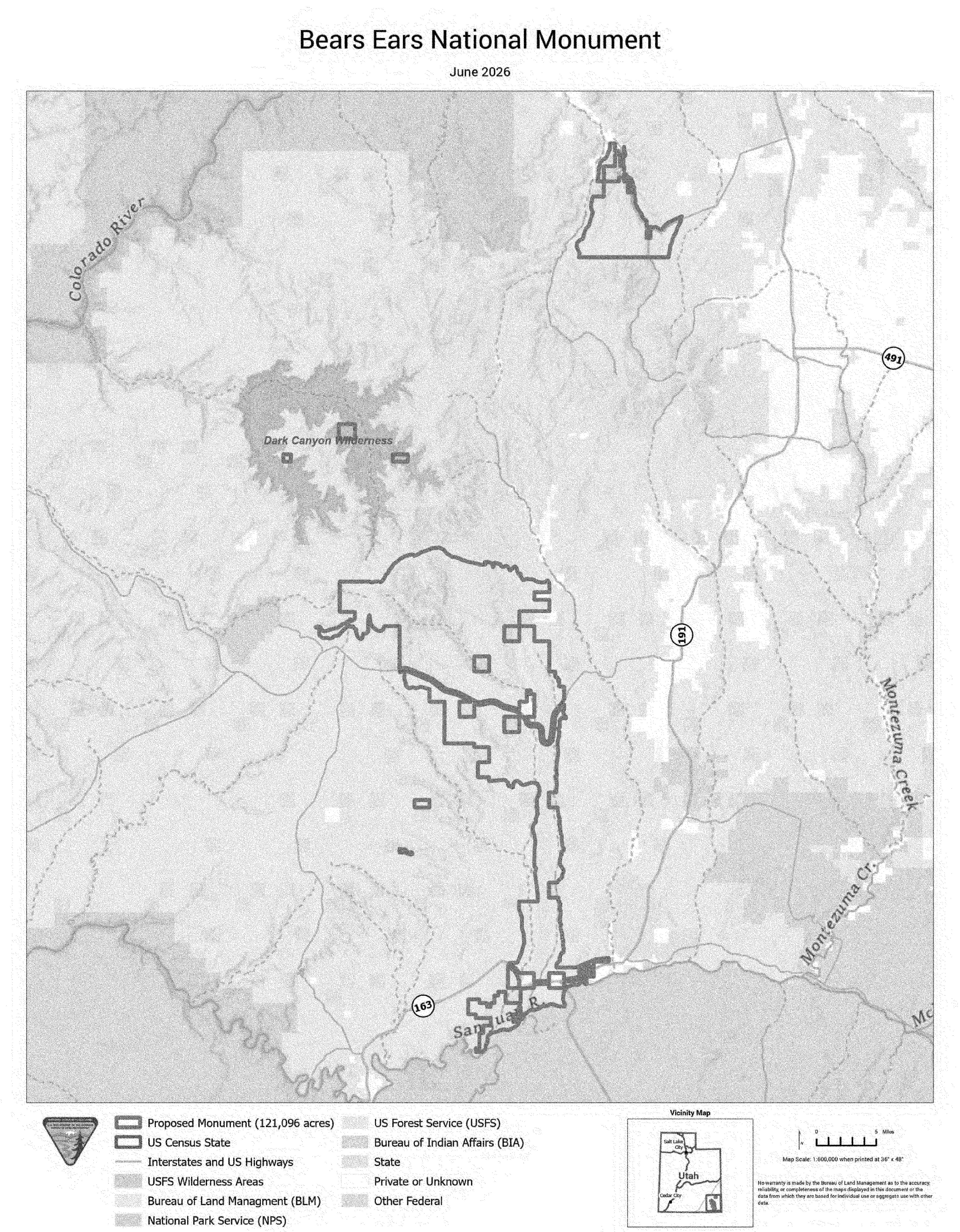
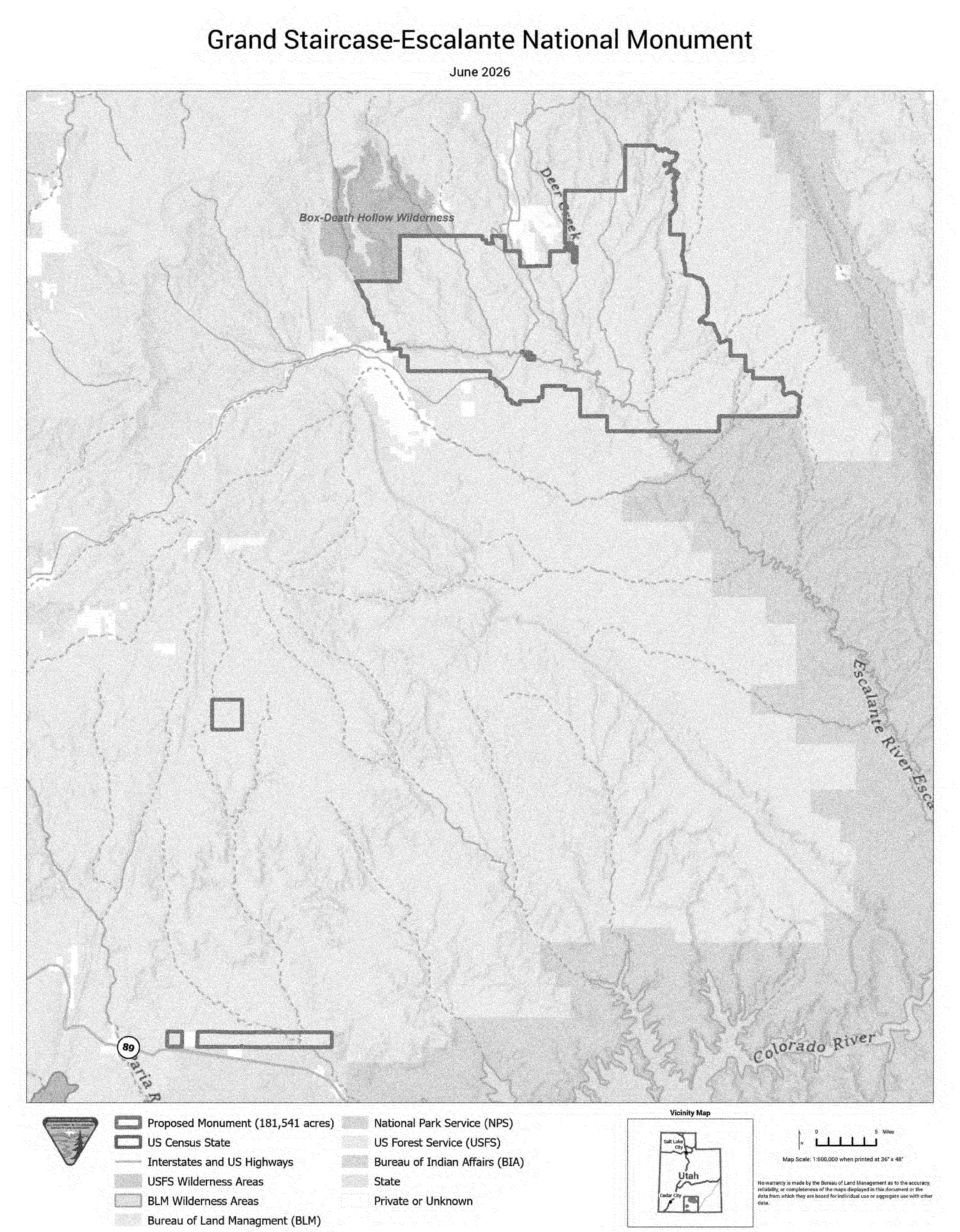
So the picture is complete in a way it wasn't for the first three weeks. We know precisely how much came out — 1,238,904 acres from Bears Ears and roughly 1.69 million from Grand Staircase-Escalante — and we can now draw, from the government's own coordinates, which acres those were. The one thing still missing is trivial by comparison: the records carry no unit names, so "Shash Jáa" and "Kaiparowits Horizon" exist on the paper maps and in the proclamation text but not yet in the data.
The practical caution hasn't changed, though. A boundary you read off any map — ours, or the 1:600,000 originals — is not a survey. If your question is whether one particular trailhead or canyon rim sits inside or outside, ask BLM.
Which places landed outside the lines?
In the weeks since the maps published, the newsrooms that cover this country traced them against the places people actually drive to — the Salt Lake Tribune and KSL both ran annotated maps, and the climbing press did the same for Indian Creek. Those tracings are where the landmark-by-landmark list below comes from. Now that BLM's coordinates are out, the shapes those newsrooms drew by eye look right, which is reassuring but doesn't upgrade a traced landmark call into a survey.
Still inside: the Bears Ears buttes themselves, House on Fire ruin in Mule Canyon, the Sand Island petroglyphs, and — right off Byway 12 — Lower Calf Creek Falls. On the Grand Staircase side, nearly all the retained acreage sits in the single Canyons of the Escalante unit, which keeps Calf Creek Canyon, the Escalante Natural Bridge and the Boulder Mail Trail. Worth knowing before you drive out there: the retained Indian Creek parcel is the one the Babylon Fire closure sat on for most of the summer, so "inside the monument" and "open this week" were two different questions — and the second one is the one that would have changed your trip.
Now outside: Grosvenor Arch, Devils Garden and Metate Arch on Hole-in-the-Rock Road, Chimney Rock, the Paria River corridor, and — the one that keeps striking me — portions of the Grand Staircase itself, no longer inside Grand Staircase-Escalante National Monument. On the Bears Ears side: Butler Wash, both Six-Shooter peaks, Valley of the Gods, and nearly all of Cedar Mesa including Grand Gulch.
Climbing at Indian Creek deserves its own line, because the retained parcel is much smaller than the old Indian Creek unit and the split is lopsided. Mapping by Access Fund and Outdoor Alliance's GIS Lab — reported in the climbing press, and theirs rather than any newsroom's count — puts roughly 80% of Indian Creek's climbing outside the new line, on the order of 1,200 routes. The Supercrack Buttress end of the corridor stayed in. Most of the rest did not.
Read that list the way this whole article asks you to. Outside the line does not mean closed, gated, or gone. Every one of those places is still federal public land, still open, still reached by the same roads. What changes outside the line is what can happen there — mining claims and mineral leasing, open since September 11 — and even then, only where someone actually stakes one. If Devils Garden is on your list, go see Devils Garden.
Did the proclamations close anything? No
Not a thing. No visitor centers shutting, no campgrounds closing, no reduced hours, no staffing cuts, no road changes. Two months in, that still holds — the only crews reported at work because of the proclamations have been changing signs, which gets its own section below.
What the proclamations actually do is move a boundary. The land does not stop being federal public land. It leaves monument status and reverts to ordinary BLM and Forest Service multiple-use management. Nobody is putting up a fence. The roads that crossed that country on July 12 cross it now.
One distinction earlier versions of this article blurred, and it matters: all of that is a statement about the proclamations, not about the ground. Large parts of Bears Ears country were closed for most of the summer — not by any proclamation, but by fire.
The closure story is a wildfire, not a proclamation
On June 26 — seventeen days before the signing, and eighteen before I published the first version of this article — lightning started a fire in the Abajo Mountains about 25 miles southwest of Monticello. The Babylon Fire burned across Elk Ridge, the Dark Canyon Wilderness, Bears Ears National Monument and the Monticello Ranger District of the Manti-La Sal National Forest, reached 107,189 acres, destroyed five structures, put six evacuation zones on notice, became the largest active wildfire in the United States, and is Utah's first megafire in eight years. It reached 100% containment on August 12, and investigators confirmed the lightning cause.
It closed far more country than any line on a map did. On the evening of June 28 the Park Service evacuated everyone out of the Needles District of Canyonlands as the fire ran north toward Highway 211, and closed the district outright. The Forest Service shut the entire Monticello Ranger District. BLM closed its lands west of Harts Draw Road and north through the Indian Creek corridor — which is, and I don't think this can be improved on for irony, precisely the piece of Bears Ears the proclamation chose to keep.
All of it has since reopened, in stages:
- July 17 — Highway 211 reopened to the Canyonlands boundary; BLM lands north of 211 reopened; Forest Service ground southeast of Blue Mountain Ranch Road and Recapture Road reopened, Devils Campground included.
- July 18, 8 a.m. — the Needles District of Canyonlands reopened to the public.
- August 20 — the Forest Service lifted its last closure order, eleven days before it was due to expire.
The June 28 order that shut the whole Monticello Ranger District was narrowed twice — at the end of July, and again on August 13, when it was pulled back to the burn area itself for road repair and hazard-tree work, with an expiry of August 31. It didn't last that long. On August 20 the Forest Service rescinded it outright with Order #04-10-26-05-07: the Babylon Fire area "is open as of 8/20/2026," in the order's words, and every San Juan County road that was shut for the fire — Causeway, North Cottonwood, Kigalia toward Big Notch, the lot — is open with it. Seven weeks and four days after the evacuations, there is no fire closure left on the forest. Even the ordinary restrictions have since gone: the forest eased from Stage 2 to Stage 1 fire restrictions on August 28, then rescinded those outright from September 4.
Roads specifically, since that's what a trip runs on — and they did not all behave the same way:
- US 191 never closed. The through-route down the east side of all this stayed open the whole time, and SR 95 held as a closure boundary rather than closing itself. If you were driving past the region, you could.
- SR 211 closed and reopened. This is the dead-end spur off 191 that is the only paved way into the Needles and Indian Creek, so it's the road that actually matters here. It was shut during the fire's run north and reopened along its full length to the park boundary on July 17.
- The Needles backcountry roads — Elephant Hill, Lavender Canyon and Davis Canyon — are open, which is not the same as easy. As of the park's September 14 road report, Elephant Hill and Coors Hill have been dug out and you should expect obstacles and congestion, Davis Canyon wants high-clearance four-wheel drive just to reach it, and Lavender Canyon is open but impassable, on a three-to-four-foot creek crossing and deep mud. All three want high-clearance four-wheel drive. "Open" and "drivable" are not the same sentence out there.
- Beef Basin is the one loose end. For three weeks the park's report said flatly that there was no access to Beef Basin from UT 211. The September 14 edition drops that line and says only that the road is good to the Cathedral Butte trailhead and “very muddy and slick” after rain — which is not the same as saying the country beyond it is open, and I still haven't seen BLM say in so many words that its piece of the corridor is. If Beef Basin is the point of your trip, call the Monticello field office before you commit to it.
Nothing about the Babylon Fire touches Grand Staircase-Escalante or Byway 12, which are a long way west of it.
The fire is out. The water is the new problem.
Containment closed the fire story and opened a longer one. A burned slope does not hold rain, and the assessment team's read is that this country will shed water in ways it didn't before for somewhere between five and ten years, depending on how fast ground cover comes back and whether the drought breaks. Their soil survey puts about half the footprint at moderate burn severity and one acre in twenty at high — the ground that repels water rather than soaking it up. Five drainages were flagged as the likeliest to run debris: Horse Mountain, North Cottonwood Creek, Cottonwood Creek, Davis Canyon and Stevens Canyon.
The mechanism that matters to a driver is unglamorous. Burned trees and debris plug a culvert, the culvert stops taking water, and the water goes over the road instead — which can cut access behind you rather than in front of you. The emergency work going in reflects exactly that: debris racks and rock armoring at culverts, drainage repairs along roughly 65 miles of trail, and road inspections after storms rather than on a schedule.
So the practical advice for the next few seasons in Bears Ears country is the ordinary desert advice, with the volume turned up: watch the sky, don't camp in a wash, and treat a dirt road in the burn scar as something that can change during an afternoon thunderstorm. That creek across Lavender Canyon is a preview, not an anomaly. One more thing to expect: the same assessment recommends gates at the motorized entry points and closing some patches to let them regrow, so "the closure is lifted" may still mean a locked gate on a particular spur. That's recovery, not a proclamation.
The first test came sooner than anyone wanted. The last weekend of August brought the monsoon in hard: flash-flood warnings across southern Utah from the 29th through the 31st, the Escalante River running at several times its normal flow on the 31st under a flash-flood warning, and — one state line over — a flood through the bottom of the Grand Canyon that closed Phantom Ranch and, indirectly, every hotel on the South Rim (that one is in our parks article). Two weeks on, nothing in the Babylon footprint has been reported closed, and the Forest Service's only new orders on the forest are relaxations — Stage 1 fire restrictions on August 28, then none at all from September 4. A second, smaller round of storms came through on September 11 and 12: a flash-flood warning along Hole-in-the-Rock Road and Coyote Gulch on the Thursday, another over the Capitol Reef washes on the Friday, and strong cells over Monticello and US 191 — statements only, no warning on the burn scar, and no washout reported anywhere in the area. Grand Staircase-Escalante took the August storms harder, and its road report shows the recovery: the September 4 edition had Cottonwood Canyon Road "not recommended" and White House Road closed past the Nautilus parking area for washout repair; the September 11 edition has Cottonwood back to high-clearance with debris-flow ruts and White House needing "only normal clearance," while Skutumpah stays "not recommended," Wolverine Loop is passable "if it stays dry," and Left Hand Collet and Smoky Hollow are still impassable. None of those is a closure order; they are what a wet week does to dirt roads, and they change again with the next one. But a burn scar's first big storm is the one to be somewhere else for, and this was it.
All of which is the thing worth carrying away from this whole article: if you are driving to Bears Ears this fall, what the fire left behind can still affect your trip, and the boundary change mostly cannot.
The signs came down
For the first week and a half, the proclamations moved lines on paper and the country looked exactly as it had. Then, around July 22, Bureau of Land Management crews removed the seals of five tribal nations from Bears Ears' roadside signs and began relocating boundary signs to match the new lines. By July 28 it had spread to the other monument: Grand Staircase-Escalante signs had been taken down at a minimum of five gateway locations. Conservation groups objected that some of what came down was visitor-safety signage, not just insignia.
The seals — Hopi Tribe, Navajo Nation, Ute Indian Tribe of the Uintah & Ouray Reservation, Ute Mountain Ute Tribe, and Pueblo of Zuni — went up in 2022 under a cooperative agreement that made Bears Ears the first national monument in the country formally co-managed with tribal nations, through a body called the Bears Ears Commission. It's easy to miss in the acreage arithmetic, but the July 13 proclamation didn't just move the Bears Ears boundary, it terminated that commission. BLM's stated reason for taking the seals down is exactly that — the commission the seals represented no longer exists.
The five tribes say the Interior Department had committed in writing, in 2025, to consult the commission before any boundary decision, and that no consultation happened. Their joint statement, issued the day after the signing, reads in part: "No political decision can sever our connection to this place, erase our histories, or diminish our responsibility to care for it."
Does any of this change a trip? No. A seal on a sign closes nothing, and the roads and ruins are where they were. But if the measure of this article is "what actually changed," the honest ledger now runs to four entries: the boundaries, the commission, the signs, and the boundary data catching up to all three.
One thing here is aimed squarely at drivers
Buried in the Bears Ears proclamation is a directive that got almost no coverage and is more relevant to this site than anything else in the document. It orders Interior and Agriculture to prepare a new transportation plan for the monument — one that "endeavors to maximize public access" by designating roads and trails for motorized and non-motorized use and providing for their maintenance.
In the meantime, the proclamation grants interim authority to allow motorized use on routes that were designated before the monument was created in 2016, and to designate additional motorized routes while the new plan is being written.
No deadline is attached, so there is nothing to watch for on a calendar. But it means the road and trail network out there is genuinely in play in a way it hasn't been for a decade — plausibly toward more legal motorized access, not less. That cuts against the shape of the rest of this story, and it would be dishonest to leave it out because it doesn't fit the narrative. If you ride or drive dirt in San Juan County, this is the paragraph to keep an eye on.
The lawsuits came on September 2
Fifty-one days after the signing — seven weeks and two days — the challenge reached a courtroom, and it got there by the route I'd flagged as possible rather than by filing anything new. On September 2 two coalitions of conservation groups asked the U.S. District Court for the District of Columbia to reopen the cases they brought against the 2017 reductions, which have been on hold since the monuments were restored in 2021, and to let them add this year's proclamations to those complaints. The mechanism, to be precise about it, is a motion per case to reopen and lift the stay, with the request to file a supplemental complaint attached as a proposed filing that still needs the court's leave. Nothing new has been sued over yet; the door has been knocked on.
The two groups line up much as they did in 2017. One, on the Bears Ears case, is led by the Conservation Lands Foundation with Utah Diné Bikéyah, Archaeology Southwest, Patagonia, the Access Fund, the National Trust for Historic Preservation and the Society of Vertebrate Paleontology. The other, represented by Earthjustice and covering both monuments, is The Wilderness Society, the National Parks Conservation Association, the Sierra Club, Grand Canyon Trust, the Center for Biological Diversity and others, with NRDC and the Southern Utah Wilderness Alliance filing alongside on their own behalf. The argument is the one that never got decided last time: the Antiquities Act lets a president create a monument and says nothing about shrinking one.
Two things to keep straight. First, the five tribes have not filed anything of their own. They led in 2017 and their case is still on the same docket, but they did not join the September 2 motions. What they have done is go on the record: a joint status report filed on September 8 — the government's document, signed with the consent of every party, the tribes' lawyers at the Native American Rights Fund and the Navajo Nation among them — states that the Hopi Tribe and its co-plaintiffs “support the motions.” The same report says the government and the intervenors on its side (Utah, the Farm Bureaus, a set of sportsmen's groups) are “evaluating” the motions, and on September 9 Judge Tanya Chutkan gave them until September 16 to answer. That is the first real date on the court calendar, and the first thing next week's pass will look for. Second — and this is the part that matters for a trip — nothing has been stayed or enjoined, and nobody has asked for an injunction. A motion doesn't move a boundary. The reduced monuments stand, the September 11 opening went ahead on schedule, and the court has not yet said whether it will take the cases back up at all. The White House's response was a statement that earlier administrations had "abused" the Act and that the President had "rightsized" the monument.
Does it change a trip? No. What it changes is the shape of the story. For seven weeks the question was whether anyone would sue. Now it is whether a court will let them, and how long that takes — and the last time these cases were live, the answer was four years and no ruling.
A second front opened on the management plan
This one is a little technical, so bear with me. Separate from the boundary, Bears Ears has a management plan — the document that says how the land inside the line is actually run: which routes are open, where you can camp, how grazing and climbing and cultural sites are handled. The current one took effect in January 2025, written for the big monument under tribal co-management. It still governs what's left, because no replacement has been written.
On August 17 the Government Accountability Office, at Senator Mike Lee's request, posted an opinion that this plan counts as a "rule" under the Congressional Review Act and was never submitted to Congress as one. The practical effect is procedural but real: it lets Utah's delegation introduce a resolution to repeal the plan on a fast track, with a simple majority and no filibuster — and if that passed, the agencies would be barred from issuing anything "substantially the same." The same tactic was tried against the Grand Staircase-Escalante plan earlier this year and failed in the Senate on June 12. As of September 14 no resolution has been introduced against the Bears Ears plan.
Does it change a trip? Not today. A management plan isn't a gate, and repealing one doesn't close a road. But if you want to know where the next real change to how this country is run will come from, it's at least as likely to be here as in any courtroom — so it goes on the watch list.
What happened on September 11, 2026?
There is a detail in the proclamations that most of the coverage ran straight past.
The boundary change took effect on signing. The land reopening did not. The excised acreage did not open to mineral leasing, geothermal leasing, or mining entry until 9:00 a.m. Eastern on the date sixty days after signing — which was September 11, 2026.
So the reporting about three million acres opening to mining immediately was wrong for sixty days. That window closed on the morning of the 11th. From that hour the removed land is open to mineral entry and leasing, subject to existing rights and withdrawals, and the plain description of it is the ordinary one: BLM multiple-use land on which someone can stake a claim. BLM never posted a Federal Register notice or a news release about the opening. Its one public statement came two days before, in a written reply to KSJD, the public radio station in Cortez: "If we receive mineral-related proposals at that time, we'll evaluate them carefully and transparently, consistent with federal regulations." Its Monticello field manager had told the San Juan County commissioners in August to expect "not a lot of changes actually on the landscape immediately," and the agency says it will spend about a year and a half writing a new management plan for what remains of the monument and the land cut from it, running the existing 2025 plan in the meantime.
That is the right frame for the date. Opening land to mineral entry is not a mine. A claim is a filing at a county recorder's office; a mine needs a plan of operations, an environmental review and a permit, and none of that happens in a morning. Three days after the opening, nobody has reported a claim staked on or after it — not the groups that found the early ones, not the local press, not BLM, whose KSJD reply is still the only thing it has said. I would not read much into that yet. A claim is staked on the ground first and recorded afterward, and the law gives a locator weeks to get the paperwork in, so the first post-opening filings will surface the way the early ones did, through the county recorders in San Juan, Kane and Garfield counties, and probably not all at once. That is the thread to keep pulling.
Somebody didn't wait
Here is the part that made the sixty-day clause more than a technicality. Claims were filed on the removed land before the date.
- Seven claims recorded with the San Juan County Recorder by Kimmerle Mining, within about a day of the Bears Ears reduction.
- Two claims recorded with the Kane County Recorder on August 6, on ground cut out of Grand Staircase-Escalante.
Nine claims, all of them before September 11. The proclamations anticipated this and said so in terms that leave little room: appropriation of the land under the mining laws before the restoration date and time "is unauthorized," and any such attempted appropriation "shall vest no rights against the United States." Earthjustice, which surfaced the county filings, argues BLM should reject them outright. BLM has said nothing about them publicly, and no further filings have turned up in the coverage — the count is still nine. Now that the date has passed, the early ones matter less than they did: a claim that was unlawful to stake on the 10th could be lawfully re-staked on the 11th, so whether the nine are rejected or quietly refiled is a paperwork question, not a land question.
I want to be careful about what this does and doesn't mean, because it is the kind of story that gets over-read in both directions. Recording a claim at a county office is cheap and it is not the same as permission to dig — no approval has been granted, no ground has been broken, and on the face of the proclamations these particular filings are worth nothing. What it does tell you is that the interest in this acreage is not hypothetical and not slow. People were filing paperwork on it inside of a day.
For a trip, this still changes nothing. Every acre involved is open public land you can drive to, and an open claim doesn't close a road. It is on this page because the honest version of "what happened on September 11" includes the fact that some people tried not to wait for it.
And a question about the week before the signing
Separately, and worth flagging with its caveats attached: on August 10 two Democrats on the House Natural Resources Committee opened an inquiry into whether executives at the uranium producer Energy Fuels traded on advance knowledge of the Bears Ears decision. The company's chief executive bought 74,000 shares on July 7 — reported as the largest insider purchase in the company's history — and its chairman bought 4,000 the next day. The proclamation came on July 13. The company operates the White Mesa Mill, which sat about a mile outside the old monument boundary, and it rejects any suggestion of wrongdoing. The committee members asked for the company's records by August 24. The company sent a letter, but by the members' account it neither answered the allegation nor produced the records, and no new deadline has been set; the company, for its part, says the purchases were cleared by its own compliance process, filed with the SEC, and that Bears Ears is immaterial to its business. Where that goes next depends on who controls the committee after November, which is the members' own framing.
An opened inquiry is not a finding, and letters from the minority side of a committee carry no legal force. I include it because the timing is a matter of public record and because it is the one thread on this story that might eventually produce a document nobody intended to release. It has nothing to do with whether you can drive out there, which remains yes.
Is Scenic Byway 12 affected? No
We have a route that goes straight through this. Epic Trip #11, The Painted Mile — Scenic Byway 12 from Torrey down to Bryce Canyon City, 116 miles. Grand Staircase-Escalante is one of its signature stops.
It runs as it always has. Byway 12 is a state highway, a monument boundary does not close a state highway, and nothing in either proclamation touches the road. Capitol Reef and Bryce Canyon are national parks on either end of it and are not affected by any of this.
If that drive was on your list, leave it there. If anything, the shoulder season ahead is the good time to go — see our notes on building a trip around a park for the timing.
Where to follow this from here
I wrote this the day after the signing; it gets a fresh pass weekly, and the change log at the bottom records each one. Between passes, four things can move faster than we do:
- The weather over the burn scar. With the closure order gone, nothing on paper stands between you and the Babylon footprint — which means the thing to watch now isn't an order at all, it's the forecast. A storm over fresh burn is what will close a road out there this fall, and it will do it without a press release.
- The court, and the tribes. The conservation groups filed on September 2; the five tribes have said they support the motions but filed nothing of their own. The government's response is due September 16. After that, the things to watch are whether the D.C. court agrees to reopen the 2017 cases at all, and whether anyone asks it to stop the clock — nobody has yet, and until someone does the boundaries stand.
- What follows September 11. The one date in the proclamations has passed and the removed land is open to claims. The things to watch now are the county recorders in San Juan, Kane and Garfield counties for new filings, and whether BLM ever says what it intends to do with the nine early ones.
- A repeal resolution on the management plan. The GAO opinion is the starting gun; watch for a Congressional Review Act resolution from Utah's delegation, and remember the Grand Staircase one failed.
Only the first of those is a reason to change a trip. The rest are reasons not to treat any one week's version of this article as the last word. If you want the current state of things rather than our latest pass at it, here is where we are watching:
- BLM Utah — the agency that actually manages both monuments, and where road and campground conditions live. Worth a look before any trip out into that country, news or no news.
- Manti-La Sal National Forest alerts — where the closure was lifted, and where a re-closure for storm damage would show up first.
- Canyonlands road conditions — the page that told us Elephant Hill, Lavender and Davis Canyon had reopened, and the one to check for the mud and washouts that will keep changing which of them you can actually drive.
- The Federal Register — the proclamations and their official maps.
Has this happened before? Yes — in 2017
One last thing, offered as history rather than argument.
In December 2017 these same two monuments were cut by proclamation — Bears Ears by about 85%, Grand Staircase by about 47%. In October 2021 President Biden restored both. The 2026 cuts are the deeper of the two rounds.
Every lawsuit against the 2017 reductions was shelved after the 2021 restoration — put on hold, never decided — before any court reached the merits. That is why they could be reopened this month. Which means no court has ever ruled on the question underneath all of this: whether a president who can create a monument can also shrink one. The Antiquities Act of 1906 says a president may declare monuments, and directs that they be confined to the smallest area compatible with caring for the objects protected. It says nothing explicit about undoing one.
There is one contrast between the two rounds that I keep turning over. In 2017 the litigation was instant: five tribal nations sued the same day the proclamation was signed, and a nine-group conservation coalition followed three days later. This time the same organizations, several of them literally the same plaintiffs, took seven weeks and two days — and the tribes, who led in 2017, have still not filed. I don't know why, and I'd rather say that than invent a reason; a deliberately slower, better-built filing is one explanation, and there are others. But the difference is real, and if you are tracking one number on this story, the gap between "three days" and "fifty-one" is a more interesting one than ninety percent.
The pattern is now repeating from the other direction, and the timing borders on comic. On June 23 — twenty days before these proclamations — the Tenth Circuit revived Utah's long-running lawsuit arguing the restored monuments were unlawfully large. Then the map changed underneath it, and that case is now reported to be likely moot for the same reason the 2017 cases died: the thing being litigated stopped existing mid-suit. A decade of litigation over these two monuments, and every case so far has been killed by a boundary change before any court could reach the question.
That question is still open. It may finally get an answer this time.
Change log
- September 14 — Weekly pass, three days after the opening. The court thread moved, on September 8–9 rather than this weekend: the government’s joint status report says it is “evaluating” the motions to reopen and records that the five tribes “support” them; Judge Chutkan set September 16 for the government and intervenors to respond — the status box, takeaways, lawsuits section and watch list now carry all of that, and the mechanism is stated more precisely (motions to reopen and lift the stay, supplemental complaints attached as proposed, not yet filed). No claim staked on or after September 11 has been reported by any group, outlet or BLM; the “as I write this on the morning of the 11th” passage is re-tensed and now says why silence three days on means little. Both road reports re-issued: Canyonlands’ Needles report of September 14 drops its “no access to Beef Basin from UT 211” line (now: good to Cathedral Butte, muddy after rain, nothing about beyond) — the body’s road bullets, which had been citing an August 14 edition while the status box cited August 24, are now both on the 14th; Grand Staircase-Escalante’s September 11 report has Cottonwood Canyon and White House Road eased, Skutumpah, Left Hand Collet and Smoky Hollow unchanged, Hole-in-the-Rock in deep sand. The September 11–12 storms added: a flash-flood warning on Hole-in-the-Rock Road, none on the burn scar, no washouts reported. BLM boundary acreage re-checked and unchanged; Federal Register, Congress (no CRA resolution) and the Energy Fuels inquiry re-checked and unchanged. Also fixed two stray backslashes that had been rendering in the road-reports row since it was written.
- September 11 — Weekly pass, on the day. The removed land opened to mining claims and mineral leasing at 9 a.m. Eastern, sixty days after signing; the countdown language in the takeaways, status box, the September 11 section and the watch list is re-tensed to past. BLM published no notice or release; its written reply to KSJD radio on September 9 and its Monticello field manager's "not a lot of changes on the landscape immediately" are now quoted, along with the roughly eighteen-month plan-writing timeline. No claim staked on the day had been reported by the morning of the 11th; the nine early claims stand at nine, with the note that a claim unlawful on the 10th could be lawfully re-staked on the 11th. The tribes' position clarified — still on the 2017 docket, not party to the September 2 motions. Boundary service, Federal Register, Canyonlands road report (still August 24), Manti-La Sal alerts (nothing new for the Monticello district) and Congress re-checked, unchanged.
- September 8 — Weekly pass. The lawsuits arrived: on September 2 two conservation coalitions moved in the D.C. federal court to reopen the 2017 cases and add the 2026 proclamations to them; new section, status row, takeaway, watch-list bullet and the 2017 comparison all rewritten around it. The five tribes have not filed. Manti-La Sal rescinded its fire restrictions September 4; Canyonlands' road report is still the August 24 one (Beef Basin line unchanged); Grand Staircase-Escalante's September 4 road report added — Cottonwood Canyon and Skutumpah "not recommended" after the storms, Left Hand Collet and Smoky Hollow impassable. September 11 is three days out and BLM has posted nothing about the opening. Boundary data re-checked, unchanged. Energy Fuels, the nine claims and the CRA thread: no change.
- August 31 — Weekly pass. The burn scar's first big storm: flash-flood warnings across southern Utah August 29–31, the Escalante River in flood on the 31st, and the Grand Canyon flood next door; nothing in the Babylon footprint reported closed as of this pass, and the Forest Service's only new order eases fire restrictions to Stage 1. Canyonlands' road report re-issued August 24 (Beef Basin still cut off from 211, now with the Elephant Hill route as the park's suggested way round). Energy Fuels missed the August 24 deadline on the insider-trading inquiry, in the committee members' account; the company's response added. Still no lawsuit at seven weeks, still no repeal resolution, BLM still silent on the nine claims, boundary service re-checked and unchanged. The September 11 countdown moved to eleven days.
- August 23 — Weekly pass. The Babylon Fire closure is gone: on August 20 the Forest Service rescinded its burn-area order eleven days early, and every San Juan County road shut for the fire is open — so the "still closed" list is retired and the closure status reads "lifted," with Beef Basin access off 211 flagged as the one loose end from Canyonlands' August 14 road report. Added the soil-burn-severity figures and the assessment's recommendation for gates and regrowth closures. New section on the management plan: a GAO opinion posted August 17 treats the 2025 Bears Ears plan as a rule under the Congressional Review Act, opening a fast-track repeal path; no resolution introduced yet, and the Grand Staircase attempt failed June 12. Noted the August 24 response deadline on the Energy Fuels inquiry and that BLM has still said nothing about the nine early mining claims. Re-verified the BLM boundary data (unchanged). Still no lawsuit, now almost six weeks out. Trimmed the boundary-data section, which had been written as a discovery and was still saying "last week" three weeks later, and dropped a pull quote that repeated the paragraph above it.
- August 17 — Weekly pass, two weeks on from the last one. Mining claims have been filed on the removed land ahead of September 11 — nine of them, seven in San Juan County within a day of the Bears Ears cut and two in Kane County on August 6 — and the proclamations say early filings vest no rights; that is now its own section. Added the August 10 congressional inquiry into share purchases at Energy Fuels the week before the signing, with its caveats. The Babylon Fire is out — 100% contained August 12 — and the closure has been narrowed twice, most recently to the burn area alone on August 13; the Needles roads we had listed as closed to vehicles (Elephant Hill, Lavender, Davis Canyon) have reopened, so that list was wrong and is corrected, along with the BLM Indian Creek line. Added what replaces the fire: five-to-ten years of flood and debris-flow risk, five flagged drainages, and the culvert-and-washout mechanic that actually cuts a road. Also fixed a number the last fact-check missed — the opening paragraph still said the budget claim was "off by a factor of about forty" while the budget section, corrected on August 3, said ten. Re-verified the BLM boundary data (unchanged). Still no lawsuit filed, now five weeks out, which the 2017 comparison section now puts in context.
- August 3 — corrections from a full fact-check. After the pass below, we audited every claim on this page rather than only the ones we'd just edited. Four things were wrong. (1) The roads paragraph called US 191, SR 95 and SR 211 closure perimeters "rather than being closed themselves," contradicting the reopening timeline directly above it — SR 211 was closed and reopened July 17; 191 and 95 are the ones that stayed open. (2) The budget section said the real BLM appropriation was "off by about thirty-eight times" from a hypothetical 90% cut. It's about ten times. A bad multiplier in the section debunking bad multipliers. (3) The Indian Creek climbing estimate was credited to "Climbing magazine's count" — the mapping is Access Fund and Outdoor Alliance's GIS Lab; the magazine reported it. (4) The "BLM Utah" link in the watch list had been dead (404) since publication. Also reconciled a contradiction where the retained Indian Creek parcel was described as keeping "the Creek's core corridor" two paragraphs above the line saying 80% of its climbing fell outside.
- August 3 — Weekly pass, and the biggest one since publication. BLM published the new boundary data — found on the weekly re-check, verified against the proclamations' acreages, and the interactive map is now redrawn from it showing what was removed against what remains. Added the Babylon Fire, a 107,000-acre wildfire that has been closing large parts of Bears Ears since June 26 and that this article should have covered from day one; corrected the unqualified "nothing is closed" framing accordingly. Added the proclamation's transportation-plan directive, the Grand Staircase sign removals, and fire-status sources to the watch list. Still no lawsuit filed.
- July 27 — Weekly pass. Still no lawsuit filed; BLM boundary data still unpublished (re-verified against the live service). Added the in/out landmark tracings, the Bears Ears Commission termination and the sign changes, and the likely mooting of Utah's own lawsuit.
- July 20 — Federal Register publication folded in: proclamation numbers 11043 and 11044, the official boundary maps, and a refreshed status box.
- July 14 — Published, the day after the signing.